Routing Criteria
Standard Ship
Navigation
It is assumed that the vessel has GPS navigation capability and can sail great circle routes.
Under Keel Clearance (UKC)
A UKC of 50% draft is used in restricted waters such as port approaches.
A UKC of 100% draft is used in open oceans. Isolated shoals in open seas are normally avoided using a distance off of 8nm and in restricted waters between 2 and 5 nm.
Depths are considered to be the charted depth with no allowance for the rise of tide.
For ports where the depth is not suitable for the Standard Ship, the route in and out of the port will be determined by the maximum draft for a vessel visiting the port.
Where recommended routes with maximum drafts are given for approaching a port, the deepest draft route will always be used. (eg Finland & Sweden)
Distances Off Land
Where not specified nationally, distances off land are usually 12 nm.
In restricted waters, horizontal clearances of 5nm are accepted.
National requirements for minimum distances off coasts for transits are observed:
In restricted waters, horizontal clearances of 5nm are accepted.
National requirements for minimum distances off coasts for transits are observed:
- South Africa – Routes keep 25nm off the coast for transit purposes, except through the Traffic Separation Schemes (TSS) off Alphard Bank
- West Coast of USA – Routes keep 50nm off the coast for transit purposes
- New Zealand – Routes keep 5 nm off the coast for transit purposes
-
Australia
- Routes off the East coast of Australia keep outside the Great Barrier Reef then approach the coast via either the Palm, Hydrographers’s or Grafton Passages
- Elsewhere the transit routes keep 25nm off the coast, except when using the TSS in the Bass Strait or when transiting the Torres Strait
- Baltic – Vessels entering the Baltic from the North Sea are routed via the ‘T’ Route, East of Leasoe Island and via the Great Belt.
- Norway – The offshore TSSs are used for transit routes. There is also a coastal route for transit between Norwegian ports, and an option for obtaining distances using the inshore Indrelia route.
Oil Fields
Oil rigs/ production platforms where possible are not passed closer than 5nm. This is to prevent collision warnings and shutdowns being activated on the rig. Development and Restricted Areas are observed except when approaching a terminal within the area.
Traffic Separation Schemes
The routes used follow the requirements of IMO’s Ships’ Routeing document
The routes used will always observe Traffic Separation Schemes in the IMO document and non-IMO approved schemes.
Routes crossing traffic lanes observe the requirements of the Collision Avoidance Regulations.
Routes observe the Areas to Be Avoided (ATBAs) as promulgated by IMO and charted marine reserves prohibiting transit passage.
Where TSSs are considered to be too close to land, routes are used well to seaward of such TSSs (eg off the South and Southeast coast of Korea)
Recommended routes are observed where charted, Gulf of Mexico, Black Sea, Australia NW Coast.
Archipelagic Sea Lanes (ASL)
The routes used observe the partial ASL system adopted through Indonesian waters. These are the 3 main North to South passages. Other routes can be calculated by disabling the ASL control on certain versions of the software.
Obstructions
Dangerous wrecks and emerging shoals are avoided, but transient obstacles such as ODAS buoys and fishing reservations are not.
Chart Reliability
Routes are not calculated where chart information is considered inadequate as marked on UKHO charts, or where there is significant risk of volcanic activity affecting
depths. Reference is made to the UKHO nautical publications for this information.
depths. Reference is made to the UKHO nautical publications for this information.
Seasonal Routing
The routes used do not account for seasonal weather or ice conditions. The routes do not observe loadline seasonal zones.
Use of seasonal controls off the Canadian coast allow routing via the Tail of the Bank for North Atlantic ice avoidance.
Use of seasonal controls off the Canadian coast allow routing via the Tail of the Bank for North Atlantic ice avoidance.
Passages not used
The default routing setup prohibits use of the following passages
- Inside "Aliwal Shoal".
- Between the Kuria Muria Islands and the mainland of Arabia.
- The Bonifacio Strait, unless in ballast. *
- The Messina Straits, if of 50,000 GRT or over.*
- Taiwan Strait.*
- The Old Bahama Channel, between Cuba and the Great Bahama Bank.*
- Between Margarita Island and the mainland of Venezuela.
- Santa Barbara Channel (California)
Reciprocal Routes
The use of Traffic Separation Schemes separates the tracks proceeding in opposite directions. However, many route links used in calculating distances are reciprocal routes. This means that the routes would not be suitable for direct transfer into a passage plan and so the applications are marked “NOT SUITABLE FOR NAVIGATION”
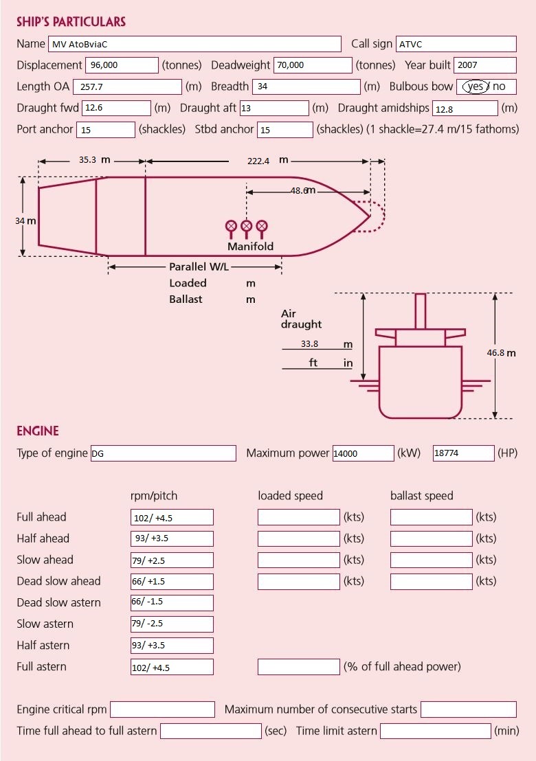
Ship's Particulars