Interacting with the Map |

|

|
|
Interacting with the Map |
|
|
Interacting with the Map |
|
|
|
Interacting with the Map |
|
|
|
The map may be zoomed in or out to display a smaller or larger geographical area, and may be panned in any direction.
In addition to simply plotting the route from which the distance is derived, the world coastline map can be used to display additional Map Overlays and Marine Information. In the example to the left, the ECA overlay and Traffic Scheme information layer have been enabled.
If required, an image of the map can be exported to a .png file. |
||
|
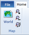
The Map section of the Home ribbon bar tab contains buttons to zoom the map to the full world extent and to Zoom In, Zoom Out and Zoom to the extent of the current route.
When zooming in or out the map will snap to one of a predetermined set of zoom levels.
As an alternative to using these controls, if you are using a mouse with a 'wheel', it can be rolled to activate the zoom action.
You can zoom in to a specific area by holding down the Left* mouse button whilst also pressing the Shift key and dragging diagonally down to the right until the highlight rectangle displayed over the map encompasses the required area.
(*) assuming the Left and Right mouse buttons are performing their default actions and have not been reversed. |
||
|
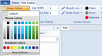
The colours used to display any map elements are full customisable by using the controls on the Map Display ribbon tab. |
||
|
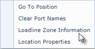
A context menu on the map provides the ability to:
➢Go To Position - positions the map at a specified geographical location ➢Clear Port Names if they have been displayed ➢Display Loadline Zone Information ➢Display Location Properties - provides further information relating to any features displayed from Marine Information overlays. |