|
|


Map - Go To Position |

|

|
|
Map - Go To Position |
|
|
|
|
Map - Go To Position |
|
|
|
Map - Go To Position |
|
|
|
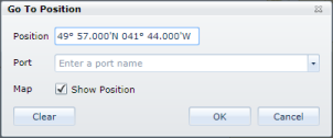
Select the 'Go To Position' option from the map context menu and a window is displayed.
The initial position is the geographical location on the map at which the mouse was clicked to display the context menu but can easily be edited to the required position by simply entering the latitude and longitude co-ordinates.
Alternatively, a position can be selected by choosing a port name from the drop down list. If the port selected is not currently included within the Distance Tables, the name and location of the nearest Distance Tables ports is also displayed on the map.
Click the Show Position check box if the entered location is to be identified on the map with an appropriate annotation. This can subsequently be cleared with the Clear Port Names option on the maps context menu. |