|
|


Ribbon - Map Display Tab |

|

|
|
Ribbon - Map Display Tab |
|
|
|
|
Ribbon - Map Display Tab |
|
|
|
Ribbon - Map Display Tab |
|
|
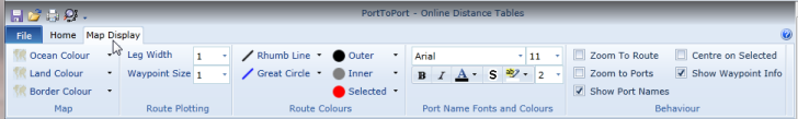
Map
|
Ocean Colour |
Click the drop down button and select the colour to be used for display oceanic areas on the map from the displayed colour palette. |
|
Land Colour |
Click the drop down button and select the colour to be used for display land areas on the map from the displayed colour palette. |
|
Border Colour |
Click the drop down button and select the colour to be used for display land borders on the map from the displayed colour palette. |
Route Plotting
|
Leg Width |
Set the width of the lines to used to draw routes on the map. The value can be between 1 and 5. |
|
Waypoint Size |
Set the size of the waypoints drawn on the map. A value of 0 to 5 can be specified. A size of zero suppresses the drawing of waypoints. |
Route Colours
|
Rhumb Line |
Click the drop down button and select the colour to be used for displaying Rhumb Lines on the map from the displayed colour palette. |
|
Great Circle |
Click the drop down button and select the colour to be used for displaying Great Circles on the map from the displayed colour palette. |
|
Outer |
Click the drop down button and from the displayed colour palette, select the waypoint outer border colour to be used when drawing a waypoint. |
|
Inner |
Click the drop down button and from the displayed colour palette, select the waypoint fill colour to be used when drawing a waypoint. |
|
Selected |
Click the drop down button and from the displayed colour palette, select the waypoint fill colour to be used when drawing a selected waypoint. |
Port Name Fonts and Colours
|
Font Name |
Click the drop down button and select the font to be used when displaying port names on the map. |
|
Font Size |
Click the drop down button and select the font size to be used when displaying port names on the map. |
|
Bold/Italic |
Toggle the button to use bold and / or italic font adornments. |
|
Font Colour |
Click the drop down button and from the displayed colour palette, select the font colour to be used when displaying the port names. |
|
Halo |
Toggle the button to use a font halo adornment around the port name. |
|
Halo Colour |
Click the drop down button and from the displayed colour palette, select the font colour to be used for the halo to be used around the port names. |
|
Halo Size |
Click the drop down button and select the halo size to be used when displaying port names on the map. |
Behaviour
The behaviour options control how the Map responds to a variety of circumstances.
|
Zoom To Route |
When checked the Map will zoom to the extent of route when it is calculated. |
|
Zoom To Ports |
When checked the Map will zoom to the extent of ports entered when adding them to a voyage or when multiple ports are selected in the Ports Data Grid view. |
|
Show Port Names |
When checked, port names are displayed on the Map. If unchecked, the port marker is displayed without the name being printed alongside it. This applies to both the ports added to the voyage list and the selected port(s) in the Ports Data Grid view. |
|
Centre On Selected |
When checked, the Map is zoomed to display the selected port in the ports data grid in the centre of the map. |
|
Show Waypoint Info |
When checked, the waypoint name, position, distance to that waypoint from the start of the voyage and ETA at that location, together with any zone information identified from a route scan is displayed overlaid in the bottom right corner of the map. |
