Calculating a Distance |

|

|
|
Calculating a Distance |
|
|
Calculating a Distance |
|
|
|
Calculating a Distance |
|
|
|
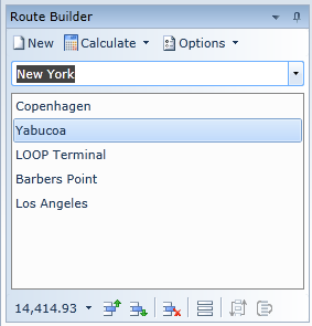
Enter the first few letters of the required port name in the Enter Port Name field and when the required port is displayed, press ENTER and the port is added to the list of voyage ports. Repeat this process for each port to be included within the voyage.
When the required list of ports is complete, click the 'Calculate' button in the toolbar and the distance will be calculated and displayed below the port list. The route will be displayed on the Map and the Voyage Details panel will display a row for each leg of the voyage indicating the individual leg distance and ETA etc.
If you are unable to locate the port you require in the drop down list, try using the Ports Grid which includes additional search capabilities and the ability to add a located port directly to this list of ports.
Some ports are known by more than one name, or have more than one valid spelling in the Latin alphabet ("alias ports"). These ports may be referred to by any of their names.
The Calculate button includes a Drop-Down option entitled 'Automatically' which if checked by clicking on it will result in the calculation being done as soon as the port list changes.
If the relevant System Option is set, pressing ENTER in the Enter Port Name field with no port selected will also cause the distance to be calculated.
If an existing port is selected within the list, the next port entered will be inserted before the selected port. In the screenshot on the left, New York will be inserted before Yabucoa.
Ports can be moved up or down or removed from the list by using the buttons in the toolbar bar at the bottom of the panel.
This panel provides considerably more functionality described in more detail in the Route Builder help topic. |