

Exploring the user interface |

|

|
|
Exploring the user interface |
|
|
Exploring the user interface |
|
|
|
Exploring the user interface |
|
|
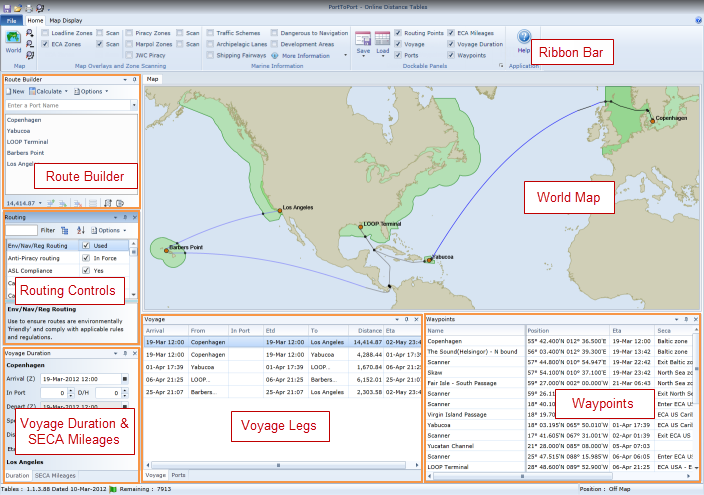
Ribbon Bar
The application uses the Microsoft fluent ribbon interface, similar in style to Microsoft Office 2007/2010 applications. It is designed to help you quickly find the commands that you need to complete a task. Commands are organised into logical groups, which are collected together under tabs. Each tab relates to a type of activity.
World Map
A coastline map of the world displays the route used by the voyage giving a visual indication of the routing used. Additionally, the map can display a number of different overlays. In the above screenshot, the ECA overlay has been enabled. Loadline, Marpol and Piracy Zones are also available for display.
Dockable Panels
The main area of the screen consists of a number of dockable panels placed around the Map which can be repositioned and re-sized as required.
Route Builder
The Route Builder panel provides the ability to select and add ports to a voyage. Within the voyage port list, ports can be added, inserted, removed or reordered. When calculated, the total voyage distance is displayed below the list together with a count of the number of distances calculated during the day and the daily limit.
Routing Control
This panel provides access to nearly 200 locations which can control how a route is calculated. If a routing point is checked in the control, it is can be used, if unchecked, then an alternative route will, if possible, be calculated by avoiding that location.
Voyage/Leg Duration
This panel provides access to the estimated time of departure from a voyage port, 'in port' time, voyage speed, weather adjustment and estimated time of arrival for either a selected voyage leg or the entire voyage.
(S)ECA Mileages
This panel is docked within the same screen area as the Voyage/Leg Duration panel in the screenshot above but can be selected when required to display total voyage mileages within and outside of (S)ECAs.
Voyage Legs
The first row displayed represents the entire voyage, subsequent rows list each leg of the voyage. The departure port, departure date and time, destination port, distance, arrival date/time and time spent in port. The Voyage Leg list can be exported to an Excel spreadsheet if required.
Waypoints
The Waypoints panel lists all major waypoints used by the route, for example, routing points and waypoints inserted when a route is scanned to identify the position, distance to/from and ETA information of the location at which a scanned zone is entered or exited. Using the list you can therefore identify the distance to the point at which you would enter a (S)ECA zone and the ETA at that location. As with Voyage Legs, this list can be exported to an Excel spreadsheet for further analysis, for example bunker calculations etc.
