|
|


Map - Loadline Zone Information |

|

|
|
Map - Loadline Zone Information |
|
|
|
|
Map - Loadline Zone Information |
|
|
|
Map - Loadline Zone Information |
|
|
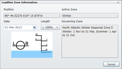
The Loadline Zone Information option on the context menu for the map is enabled if the Loadline Zone map overlay is visible.
|
The information is displayed for the geographical position on the map at which the mouse was clicked.
For those zones that vary depending on the date and size of vessel a calender date control and drop down box allow the date and length of vessel to be chosen.
The Active Zone is updated as those values are changed. |